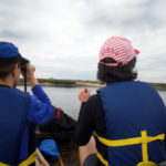
On Saturday, May 18, at dawn, SP Weather Station partnered with Marie Lorenz's Tide and Current Taxi on a water-borne dérive in Jamaica Bay. We brought along maps of flight paths and Atlantic coast bird migration routes and, very loosely, let them guide our journey. Marie's blog entry gives a pretty great overview of the day. … [Read more...]
NASA GOES captures Hurricane Sandy

Amazing images of Hurricane Sandy courtesy of NASA GOES satellites: Video from NASA GOES online here. You can also buy a print of a NASA GOES image from 20x200 with net revenue to benefit the American Red Cross - just one of many ways to help out the recovery efforts, of course. … [Read more...]
Street Sensing: seeing tiny particles
If you're in San Francisco, check out SPWS weather interpreter Tim Dye's new project 'Street Sensing: seeing tiny particles', on Saturday, October 20 as part of a tech-art event in San Francisco at the Urban Prototyping exhibition. 'Street Sensing: seeing tiny particles' will use AirCasting to crowd source air quality measurements collected by citizens. Attendees will have a … [Read more...]
Hurricane Isaac
From Rebecca J. Rosen for The Atlantic: This comes from hint.fm, a collaboration of data-visualization stars Fernanda Viégas and Martin Wattenberg. Their wind map provides a nearly real-time glimpse of the wind flow around the United States, based on hourly data drawn from the National Digital Forecast Database. "So," they write, "what you're seeing is a living … [Read more...]
Wind Map
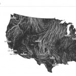
Visualization experts Fernanda Viégas and Martin Wattenberg impress again with their Wind Map project. … [Read more...]